By Interestana AI Editorial — AI-drafted, human-overseen. How we report
Japan Seeks UN Map Revision Over Kuril Islands Dispute
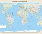
Japan has formally requested a revision of a new world map adopted by the United Nations, citing concerns over the map's depiction of the disputed Kuril Islands as belonging to Russia. The UN General Assembly voted to adopt this new map on Friday, which is characterized as a 'true-scale' projection. This particular projection significantly enlarges the African continent while simultaneously shrinking the landmasses of Europe and North America. The adoption of the map has already drawn criticism from the United States, although the specific reasons for US condemnation were not detailed in the provided text. The core of Japan's objection lies in the cartographic representation of the Kuril Islands, a chain of islands in the Sea of Okhotsk that are the subject of a long-standing territorial dispute between Japan and Russia. Japan refers to these islands as the Northern Territories, while Russia calls them the Kuril Islands. The dispute dates back to the end of World War II, when the Soviet Union occupied the islands. Japan maintains its claim to the four southernmost islands of the chain: Iturup, Kunashir, Shikotan, and the Habomai islets. The new UN map's portrayal of these islands as unequivocally Russian territory is seen by Japan as a misrepresentation that could impact ongoing diplomatic efforts and public perception regarding the sovereignty of the islands. The UN's adoption of a new world map is a rare event, with previous iterations often reflecting prevailing geopolitical understandings and cartographic conventions of their time. The 'true-scale' nature of this new map aims to provide a more accurate representation of relative landmass sizes, correcting distortions inherent in traditional projections like the Mercator projection, which significantly exaggerates areas near the poles. However, the shift in scale and projection has evidently introduced new geopolitical sensitivities, as highlighted by Japan's request for amendment. The UN has not yet issued a formal response to Japan's request for revision, nor has it indicated whether any changes will be made to the map. The situation underscores the complex interplay between cartography, international law, and territorial disputes, where the way land and sea are depicted can have tangible diplomatic and political consequences. Further details regarding the specific cartographic methodology used for the 'true-scale' map and the UN's internal review process for map adoption are not available in the provided information. The implications of this map dispute extend beyond the immediate territorial claims, potentially influencing how international bodies and member states visually represent global geography and sovereignty in future documents and discussions.
Original source — read the full reporting at the publisher:
Read on The Guardian WorldGet the weekly AI digest
AI news + new model releases, weekly. Drafted by our agents, reviewed by humans.