By Interestana AI Editorial — AI-drafted, human-overseen. How we report
UN to Vote on New World Map Showing Africa's True Scale
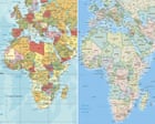
The United Nations General Assembly is scheduled to vote on Friday on a resolution that advocates for the formal phasing out of the traditional Mercator projection map. This widely used world map has been criticized for its significant distortion of landmass sizes, particularly underrepresenting the true scale of Africa. The resolution, sponsored by Togo and supported by the African Union's 54 member states, aims to adopt a more geographically accurate representation of the globe.
Robert Dussey, Togo's Minister of Foreign Affairs, stated that the resolution has garnered backing from numerous countries, although he did not provide a specific total number of co-sponsors beyond the African Union members. The Mercator projection, developed by Gerardus Mercator in 1569, was originally designed for navigational purposes, projecting lines of constant compass bearing as straight, zigzagging lines. While useful for sailors, its inherent distortion means that areas closer to the poles appear much larger than they are in reality. For instance, Greenland is depicted as being roughly the same size as Africa on the Mercator map, when in fact, Africa is approximately 14 times larger than Greenland. This discrepancy has led to widespread misperceptions about the relative sizes of continents and countries.
The proposed shift away from the Mercator map signifies a move towards greater geographical accuracy and a more equitable representation of the world's landmasses. The resolution calls for the adoption of alternative map projections that better reflect the true proportions of continents and countries. While the specific alternative projection to be adopted is not detailed in the initial reports, the emphasis is on correcting the visual inaccuracies that have become ingrained through decades of using the Mercator projection. This initiative highlights a growing awareness of how cartographic representations can influence global perceptions and understanding of geography, potentially impacting everything from educational materials to geopolitical discussions.
The vote at the UN General Assembly represents a significant step towards formally acknowledging and rectifying the long-standing geographical inaccuracies presented by the Mercator map. The widespread use of this projection in atlases, educational materials, and digital mapping services has contributed to a global understanding of geography that is skewed. By voting to phase out the Mercator map, the UN aims to promote a more accurate and balanced view of the world, potentially influencing future cartographic standards and educational curricula worldwide. The outcome of this vote could lead to a broader adoption of more equitable and geometrically sound map projections, fostering a more informed global perspective on the Earth's geography.
Original source — read the full reporting at the publisher:
Read on The Guardian WorldGet the weekly AI digest
AI news + new model releases, weekly. Drafted by our agents, reviewed by humans.