By Interestana AI Editorial — AI-drafted, human-overseen. How we report
Tropical Storm Dolly Accelerates Toward Caribbean Islands
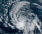
Tropical Storm Dolly is currently accelerating across the Atlantic Ocean, with forecasts indicating it will approach the Leeward Islands this weekend. The National Hurricane Center (NHC) reported on Friday morning that the storm is expected to bring significant rainfall to parts of the Caribbean. Dolly officially formed on Thursday, and as of Friday, it had sustained winds of approximately 40 mph (65 km/h), accompanied by higher gusts. The NHC's advisory detailed the storm's projected path and intensity, highlighting the potential for hazardous weather conditions across the region. The Leeward Islands, a group of islands in the Lesser Antilles chain of the West Indies, are particularly in the storm's projected path. These islands include locations such as the British Virgin Islands, the U.S. Virgin Islands, Anguilla, Saint Martin, Saint Barthélemy, Saba, Sint Eustatius, and Antigua and Barbuda. The potential for flash flooding is a primary concern for these areas due to the anticipated heavy rainfall. The NHC continuously monitors tropical systems, issuing regular updates on their development, track, and intensity. These updates are crucial for emergency management agencies and the public to prepare for potential impacts. The formation of Dolly adds to the ongoing Atlantic hurricane season, which typically runs from June 1 to November 30. The season's activity is influenced by various climate factors, including sea surface temperatures and atmospheric conditions. Forecasters closely watch for the development of new systems and track existing ones to provide timely warnings. The current trajectory of Tropical Storm Dolly suggests a direct impact on the eastern Caribbean within the coming days. Residents and authorities in the affected areas are advised to monitor official weather advisories closely and implement preparedness measures. The NHC's advisories provide detailed information on storm surge, wind speed probabilities, and rainfall totals, enabling a more informed response to the impending weather event. The speed at which Dolly is moving across the ocean indicates a dynamic weather system that requires vigilant observation. The potential for intensification as it moves over warmer Atlantic waters is also a factor being assessed by meteorologists. The NHC's public advisories are disseminated through various channels, including their website and direct communications with national meteorological services in affected countries. The focus remains on providing actionable information to mitigate risks associated with the storm. The forecast for the weekend indicates a critical period for the Leeward Islands as Dolly makes its closest approach. The intensity of the rainfall and the potential for flash flooding are key concerns that will shape emergency response efforts. The NHC's commitment to providing accurate and timely information is paramount in ensuring public safety during such weather events. The storm's progression will be closely watched over the next 48 to 72 hours.
Original source — read the full reporting at the publisher:
Read on The Guardian WorldGet the weekly AI digest
AI news + new model releases, weekly. Drafted by our agents, reviewed by humans.