By Interestana AI Editorial — AI-drafted, human-overseen. How we report
Google Maps Images Show Gaza Devastation
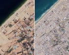
Updated Google Maps satellite imagery captured in June 2026 provides a stark visual assessment of the widespread destruction across the Gaza Strip, highlighting the ongoing humanitarian crisis affecting the territory's 2.3 million residents. These new images demonstrate further damage to residential buildings, commercial establishments, and religious sites, occurring even after a fragile ceasefire was established approximately 12 months prior to the imagery's capture. The scale of destruction depicted underscores the severe impact of prolonged conflict on civilian infrastructure and the daily lives of Gazans.
The satellite data, made available through Google Maps, allows for a comparative analysis of the territory's condition over time. By overlaying recent imagery with older maps, the extent of damage becomes quantifiable, revealing the systematic impact on urban landscapes and essential services. This visual evidence serves as a critical, albeit indirect, record of the conflict's toll, offering a perspective that complements on-the-ground reporting and official statements. The continuous updates to mapping services like Google Maps are increasingly becoming vital tools for documenting and understanding the consequences of geopolitical events and humanitarian emergencies on a global scale.
The humanitarian situation in Gaza, exacerbated by the destruction of infrastructure, presents immense challenges for its population. Access to shelter, clean water, and medical facilities is severely compromised by the damage to homes, businesses, and public utilities. The ongoing crisis necessitates significant international aid and reconstruction efforts, which are further complicated by the scale of the devastation revealed in the latest satellite imagery. The images serve as a potent reminder of the urgent need for sustained peace and comprehensive rebuilding initiatives to address the long-term consequences of the conflict on the region and its people.
Google's contribution through its mapping technology provides an accessible and verifiable method for observing and documenting the physical changes in conflict zones. While the images themselves do not detail the causes or specific events leading to the destruction, they offer undeniable evidence of its magnitude. This visual documentation is crucial for accountability, humanitarian response planning, and historical record-keeping, enabling a clearer understanding of the physical landscape's transformation due to protracted conflict. The June 2026 imagery is a significant addition to the visual archive of Gaza's current state.
Original source — read the full reporting at the publisher:
Read on The Guardian WorldGet the weekly AI digest
AI news + new model releases, weekly. Drafted by our agents, reviewed by humans.