By Interestana AI Editorial — AI-drafted, human-overseen. How we report
Hurricane Polo Rapidly Intensifies Off Mexico Coast
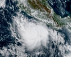
Hurricane Polo rapidly intensified into a Category 5 storm on Tuesday, boasting maximum sustained winds of 165 mph (266 km/h). The storm's center was located approximately 215 miles (346 km) south of Zihuatanejo, a coastal city in Mexico's Guerrero state. This rapid intensification is attributed to stronger than usual El Niño weather patterns currently active in the Pacific Ocean. While Polo is a powerful hurricane, current projections indicate it is unlikely to make a direct landfall on the Mexican coast. The storm's development highlights the significant impact of the prevailing El Niño conditions on tropical cyclone activity in the region. El Niño is a climate pattern characterized by the unusual warming of surface waters in the eastern tropical Pacific Ocean, which can influence weather patterns globally, including increasing the intensity and frequency of hurricanes in the eastern North Pacific. The National Hurricane Center (NHC) is closely monitoring Hurricane Polo's trajectory and intensity. The sustained winds of 165 mph place Polo among the most intense hurricanes, with Category 5 storms representing the highest level on the Saffir-Simpson Hurricane Wind Scale. This scale categorizes hurricanes based on their wind speed, with Category 5 storms having sustained winds of 157 mph or higher. The proximity of the storm to the Mexican coast, despite the current forecast of no direct impact, necessitates continued vigilance from coastal communities. Authorities are likely advising residents in vulnerable areas to stay informed about the latest updates from the NHC and local emergency management agencies. The rapid strengthening of Polo underscores the dynamic nature of tropical cyclones and the importance of accurate forecasting and timely warnings. The presence of strong El Niño conditions often leads to warmer ocean temperatures, providing more energy for hurricanes to develop and intensify quickly. This phenomenon can pose significant challenges for forecasters and emergency responders. The current situation with Hurricane Polo serves as a reminder of the ongoing threat posed by tropical storms and hurricanes, particularly in regions susceptible to their impact. The focus remains on tracking the storm's movement and providing necessary advisories to ensure public safety. The sustained winds of 165 mph are capable of causing catastrophic damage, including widespread destruction of homes, power outages, and severe disruption to infrastructure. The storm's current position means that outer bands could still bring significant rainfall and gusty winds to coastal areas of Mexico, even without a direct hit. The intensification process observed in Hurricane Polo is a critical area of study for meteorologists seeking to improve prediction models for rapid intensification events, which are notoriously difficult to forecast accurately. The strong El Niño pattern is a key factor contributing to the current atmospheric and oceanic conditions conducive to such rapid strengthening. The NHC's advisories will continue to provide detailed information on the storm's forecast track, intensity, and potential impacts.
Original source — read the full reporting at the publisher:
Read on The Guardian WorldGet the weekly AI digest
AI news + new model releases, weekly. Drafted by our agents, reviewed by humans.