By Interestana AI Editorial — AI-drafted, human-overseen. How we report
Europe's Scorched Landscapes Visible From Space
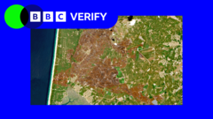
Satellite imagery has captured the widespread effects of summer heatwaves and drought across western Europe, revealing scorched landscapes and strained water resources. BBC Verify utilized remote sensing data to document the environmental toll on rivers, fields, and mountains, providing a stark visual representation of the continent's vulnerability to extreme weather events. The analysis underscores the significant impact of prolonged periods of high temperatures and reduced rainfall on natural ecosystems and agricultural lands.
Specific regions within western Europe have experienced particularly severe conditions. The Rhine River, a vital artery for shipping and industry, has seen critically low water levels, impacting transportation and economic activity. Agricultural areas are showing widespread signs of stress, with crops failing and land turning brown due to insufficient moisture. Mountainous regions, often characterized by lush vegetation, are also exhibiting signs of dryness and increased fire risk. These observations from space offer a broad perspective on the scale of the problem, complementing on-the-ground reports and scientific assessments. The data allows for a comparative analysis of different areas, identifying those most affected by the persistent heat and drought.
The phenomenon is not isolated to a single country but represents a recurring challenge across the continent, exacerbated by climate change. Scientists have linked the intensity and frequency of such heatwaves to global warming trends, emphasizing the need for adaptive strategies and mitigation efforts. The visual evidence from space serves as a powerful reminder of the tangible consequences of climate change, influencing policy discussions and public awareness. The ability to monitor these changes from orbit provides valuable data for researchers and policymakers alike, enabling a more comprehensive understanding of environmental degradation and its drivers. This perspective from above highlights the interconnectedness of environmental systems and the far-reaching impacts of climate-induced stress.
Furthermore, the long-term implications of these recurring environmental pressures are a growing concern. The sustained drought conditions can lead to desertification in some areas, altering landscapes for decades to come. The impact on biodiversity is also significant, as many species struggle to adapt to the rapidly changing conditions. The satellite data provides a crucial baseline for monitoring future changes and assessing the effectiveness of conservation and restoration efforts. The visual documentation of these environmental shifts is essential for scientific research, disaster preparedness, and international cooperation on climate action. The recurring nature of these events suggests that the observed conditions may become the norm rather than the exception, necessitating a fundamental shift in how societies manage resources and prepare for extreme weather.
Original source — read the full reporting at the publisher:
Read on BBC World NewsGet the weekly AI digest
AI news + new model releases, weekly. Drafted by our agents, reviewed by humans.